
Houston topographic map
Interactive map
Click on the map to display elevation.
About this map
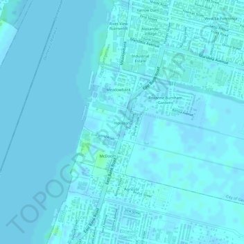
Name: Houston topographic map, elevation, terrain.
Average elevation: 1 m
Minimum elevation: -2 m
Maximum elevation: 8 m
Other topographic maps
Click on a map to view its topography, its elevation and its terrain.
Vlissengen Square Promenade
Guyana > Demerara-Mahaica > City of Georgetown > North East La Penitence
Vlissengen Square Promenade, North East La Penitence, City of Georgetown, Eccles-Ramsburg Village District, Demerara-Mahaica, Guyana
Average elevation: 2 m
Lacytown
Guyana > Demerara-Mahaica > City of Georgetown > Alberttown
Lacytown, Alberttown, City of Georgetown, Eccles-Ramsburg Village District, Demerara-Mahaica, Guyana
Average elevation: 2 m