Geolocate

Elgin topographic map

Click on the map to display elevation.

About this map

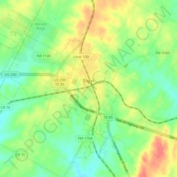
Name: Elgin topographic map, elevation, terrain.

Location: Elgin, Bastrop County, Texas, United States (30.31424 -97.43934 30.37828 -97.35623)

Average elevation: 167 m

Minimum elevation: 145 m

Maximum elevation: 197 m

Other topographic maps

Click on a map to view its topography, its elevation and its terrain.

McDade

United States > Texas > Bastrop County

Average elevation: 162 m

Cedar Creek

United States > Texas > Bastrop County

Average elevation: 125 m

Rosanky

United States > Texas > Bastrop County

Average elevation: 153 m

Antioch

United States > Texas > Bastrop County

Average elevation: 149 m

Paige

United States > Texas > Bastrop County

Average elevation: 161 m

Rosanky

United States > Texas > Bastrop County

Average elevation: 153 m

High Point

United States > Texas > Bastrop County

Average elevation: 145 m

Red Rock

United States > Texas > Bastrop County

Average elevation: 152 m

Gear up for your next adventure:

🍲Portable Camping Stoves - Fast-boiling stoves for hot meals on remote topographic survey trips
🥾Hiking Boots - Waterproof and durable boots for long-distance hiking in the UK
🧭Orienteering Compasses - Accurate compasses for map-based navigation
🔦Keychain LED Torches - Emergency backup light for finding gear in your pack
🧴Tick Removal Tools - Small, essential health tool for UK woodland and moorland

As an Amazon Associate, this site earns from qualifying purchases at no extra cost to you.