Geolocate

Prudhoe topographic map

Click on the map to display elevation.

About this map

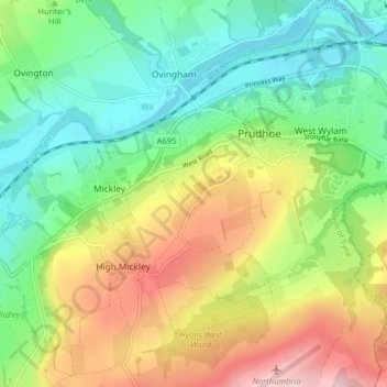
Name: Prudhoe topographic map, elevation, terrain.

Location: Prudhoe, Northumberland, North East, England, United Kingdom (54.93145 -1.90248 54.97750 -1.82242)

Average elevation: 102 m

Minimum elevation: 6 m

Maximum elevation: 258 m

Northumberland trails, hiking, mountain biking, running and outdoor activities

Other topographic maps

Click on a map to view its topography, its elevation and its terrain.

Otter Burn

United Kingdom > England > Northumberland > Prudhoe

Average elevation: 78 m

Gear up for your next adventure:

🌂Windproof Trekking Umbrellas - Surprising but effective rain protection on low-wind trails
🗺️Scratch-off Peak Maps - Track your progress climbing Munros or Wainwrights
📻Hand-Crank Emergency Radios - Stay updated on weather warnings in remote areas
🧺Mesh Stuff Sacks - Breathable storage for wet gear or camp organization
🧊Insulated Flasks - Keeps drinks hot or cold during hikes

As an Amazon Associate, this site earns from qualifying purchases at no extra cost to you.