Geolocate

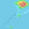
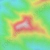
Parque Agari topographic map

Click on the map to display elevation.

About this map

Name: Parque Agari topographic map, elevation, terrain.

Location: Parque Agari, Paranaguá, Região Geográfica Imediata de Paranaguá, Região Geográfica Intermediária de Curitiba, Paraná, Região Sul, Brasil (-25.57149 -48.57848 -25.55946 -48.56351)

Average elevation: 10 m

Minimum elevation: 0 m

Maximum elevation: 22 m

Other topographic maps

Click on a map to view its topography, its elevation and its terrain.
Morro das Encantadas

Brasil > Paraná > Paranaguá

Average elevation: 8 m

Ponta do Caraguatá

Brasil > Paraná > Paranaguá

Average elevation: 8 m

Morro do Miguel

Brasil > Paraná > Paranaguá

Average elevation: 10 m

Ilha do Mel

Brasil > Paraná > Paranaguá

Average elevation: 34 m

Paranaguá

Brasil > Paraná > Paranaguá

Average elevation: 60 m

Morro do Pico Torto

Brasil > Paraná > Paranaguá

Average elevation: 507 m

Alexandra

Brasil > Paraná > Paranaguá

Average elevation: 13 m

Gear up for your next adventure:

💧Hydration Reservoirs - Convenient water bladders for hands-free drinking on the move
🧺Mesh Stuff Sacks - Breathable storage for wet gear or camp organization
🪓Outdoor Multitools - Versatile tools for hiking and camping
👕Technical Hiking Tees - Moisture-management for high-exertion climbs
🛰️Satellite Messengers - Emergency communication devices for areas without mobile signal

As an Amazon Associate, this site earns from qualifying purchases at no extra cost to you.