
Make a donation
Gear up for your next adventure:
As an Amazon Associate, this site earns from qualifying purchases at no extra cost to you.
Tory Hill topographic map
Click on the map to display elevation.
Make a donation
Gear up for your next adventure:
As an Amazon Associate, this site earns from qualifying purchases at no extra cost to you.
About this map
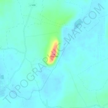
Name: Tory Hill topographic map, elevation, terrain.
Average elevation: 35 m
Minimum elevation: 24 m
Maximum elevation: 104 m
Make a donation
Gear up for your next adventure:
As an Amazon Associate, this site earns from qualifying purchases at no extra cost to you.
Other topographic maps
Click on a map to view its topography, its elevation and its terrain.
Curraghchase
Ireland > County Limerick > The Municipal District of Adare — Rathkeale
Average elevation: 34 m
Courtmatrix
Ireland > County Limerick > The Municipal District of Adare — Rathkeale
Average elevation: 39 m
Askeaton
Ireland > County Limerick > The Municipal District of Adare — Rathkeale
Average elevation: 13 m
Make a donation
Gear up for your next adventure:
As an Amazon Associate, this site earns from qualifying purchases at no extra cost to you.
Deelish
Ireland > County Limerick > The Municipal District of Adare — Rathkeale
Average elevation: 45 m
Kilmacow
Ireland > County Limerick > The Municipal District of Adare — Rathkeale
Average elevation: 94 m
Ballyneety
Ireland > County Limerick > The Municipal District of Adare — Rathkeale
Average elevation: 70 m
Make a donation
Gear up for your next adventure:
As an Amazon Associate, this site earns from qualifying purchases at no extra cost to you.
Gortroe
Ireland > County Limerick > The Municipal District of Adare — Rathkeale
Average elevation: 42 m
Ballingarry
Ireland > County Limerick > The Municipal District of Adare — Rathkeale
Average elevation: 94 m
Bleach Lough
Ireland > County Limerick > The Municipal District of Adare — Rathkeale
Average elevation: 10 m
Granagh
Ireland > County Limerick > The Municipal District of Adare — Rathkeale
Average elevation: 90 m
Make a donation
Gear up for your next adventure:
As an Amazon Associate, this site earns from qualifying purchases at no extra cost to you.
Knockpatrick
Ireland > County Limerick > The Municipal District of Adare — Rathkeale
Average elevation: 89 m
Knockdromin
Ireland > County Limerick > The Municipal District of Adare — Rathkeale
Average elevation: 30 m
Creeves
Ireland > County Limerick > The Municipal District of Adare — Rathkeale
Average elevation: 30 m
Make a donation
Gear up for your next adventure:
As an Amazon Associate, this site earns from qualifying purchases at no extra cost to you.
Finnoo
Ireland > County Limerick > The Municipal District of Adare — Rathkeale
Average elevation: 88 m
Dromard
Ireland > County Limerick > The Municipal District of Adare — Rathkeale
Average elevation: 39 m
Enniscoush
Ireland > County Limerick > The Municipal District of Adare — Rathkeale
Average elevation: 38 m
Knockbweeheen
Ireland > County Limerick > The Municipal District of Adare — Rathkeale
Average elevation: 120 m
Make a donation
Gear up for your next adventure:
As an Amazon Associate, this site earns from qualifying purchases at no extra cost to you.
Flean Beg
Ireland > County Limerick > The Municipal District of Adare — Rathkeale
Average elevation: 109 m
Knockpatrick
Ireland > County Limerick > The Municipal District of Adare — Rathkeale
Average elevation: 89 m
Rossard
Ireland > County Limerick > The Municipal District of Adare — Rathkeale
Average elevation: 56 m
Make a donation
Gear up for your next adventure:
As an Amazon Associate, this site earns from qualifying purchases at no extra cost to you.
Rathkeale
Ireland > County Limerick > The Municipal District of Adare — Rathkeale
Average elevation: 38 m