
Bienenwerder topographic map
Interactive map
Click on the map to display elevation.
About this map
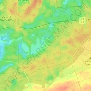
Name: Bienenwerder topographic map, elevation, terrain.
Average elevation: 63 m
Minimum elevation: 43 m
Maximum elevation: 78 m
Other topographic maps
Click on a map to view its topography, its elevation and its terrain.
Maxsee
Deutschland > Brandenburg > Märkisch-Oderland > Müncheberg > Maxseesiedlung
Maxsee, Maxseesiedlung, Müncheberg, Märkisch-Oderland, Brandenburg, 15374, Deutschland
Average elevation: 52 m
Dahmsdorf
Deutschland > Brandenburg > Märkisch-Oderland > Müncheberg
Dahmsdorf, Müncheberg, Märkische Höhe, Märkisch-Oderland, Brandenburg, 15377, Deutschland
Average elevation: 54 m