
Victoria Peak topographic map
Interactive map
Click on the map to display elevation.
About this map
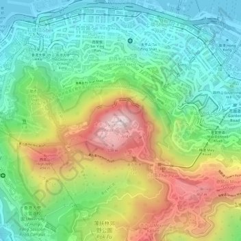
Name: Victoria Peak topographic map, elevation, terrain.
Location: Victoria Peak, Hong Kong Island, Hong Kong, China (22.27599 114.14541 22.27609 114.14551)
Average elevation: 209 m
Minimum elevation: -2 m
Maximum elevation: 534 m
Victoria Peak is a hill on the western half of Hong Kong Island. It is also known as Mount Austin, and locally as The Peak only generally. With an elevation of 552 metres (1,811 ft), it is the tallest hill on Hong Kong Island, and the 29th tallest in the territory of Hong Kong. It is a major tourist attraction offering views of Central, Victoria Harbour, Lamma Island and the surrounding islands.
Other topographic maps
Click on a map to view its topography, its elevation and its terrain.
Braemar Hill
China > Hong Kong > Hong Kong Island
Braemar Hill, Hong Kong Island, Hong Kong, 000000, China
Average elevation: 89 m
Pok Fu Lam Reservoir
China > Hong Kong > Hong Kong Island
Pok Fu Lam Reservoir, Telegraph Bay, Pok Fu Lam, Southern District, Hong Kong Island, Hong Kong, China
Average elevation: 192 m
Tai Tam Mound Waterfall
China > Hong Kong > Hong Kong Island
Tai Tam Mound Waterfall, Southern District, Hong Kong Island, Hong Kong, China
Average elevation: 150 m
Wong Chuk Hang San Wai
China > Hong Kong > Hong Kong Island > Wong Chuk Hang San Wai
Wong Chuk Hang San Wai, Southern District, Hong Kong Island, Hong Kong, China
Average elevation: 116 m
Sai Wan
China > Hong Kong > Hong Kong Island
Sai Wan, Central and Western District, Hong Kong Island, Hong Kong, China
Average elevation: 81 m
Southern District
China > Hong Kong > Hong Kong Island
Southern District, Hong Kong Island, Hong Kong, China
Average elevation: 36 m
Victoria Park
China > Hong Kong > Hong Kong Island
Victoria Park, Causeway Bay, Wan Chai District, Hong Kong Island, Hong Kong, China
Average elevation: 64 m