
Heisterbacherrott topographic map
Interactive map
Click on the map to display elevation.
About this map
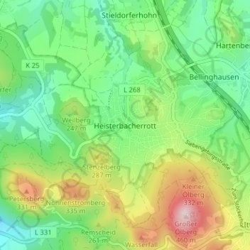
Name: Heisterbacherrott topographic map, elevation, terrain.
Average elevation: 211 m
Minimum elevation: 91 m
Maximum elevation: 436 m
Other topographic maps
Click on a map to view its topography, its elevation and its terrain.
Uthweiler
Germany > North Rhine-Westphalia > Rhein-Sieg-Kreis > Königswinter > Uthweiler
Uthweiler, Königswinter, Rhein-Sieg-Kreis, North Rhine-Westphalia, 53639, Germany
Average elevation: 157 m