
Abali topographic map
Interactive map
Click on the map to display elevation.
About this map
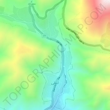
Name: Abali topographic map, elevation, terrain.
Location: Abali, Rudehen District, Damavand County, Iran (35.75395 51.95381 35.78621 51.97019)
Average elevation: 2,313 m
Minimum elevation: 2,000 m
Maximum elevation: 2,905 m
Other topographic maps
Click on a map to view its topography, its elevation and its terrain.
Rudehen
Rudehen, Rudehen District, Damavand County, Tehran Province, 39731-88981, Iran
Average elevation: 1,797 m
Central District (Damavand County)
Central District (Damavand County), Damavand County, Tehran Province, Iran
Average elevation: 1,951 m
Rudafshan
Iran > Damavand County > دهستان ابرشیوه > Rudafshan
Rudafshan, دهستان ابرشیوه, Central District (Damavand County), Damavand County, Tehran Province, Iran
Average elevation: 2,078 m
Abali
Iran > Damavand County > دهستان آبعلی > Abali
Abali, دهستان آبعلی, بخش رودهن, Damavand County, Tehran Province, Iran
Average elevation: 2,343 m