Geolocate

Koster topographic map

Click on the map to display elevation.

About this map

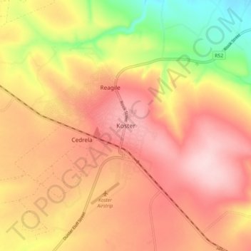
Name: Koster topographic map, elevation, terrain.

Location: Koster, Kgetleng River Local Municipality, Bojanala Platinum District Municipality, North West, 8348, South Africa (-25.89944 26.85722 -25.81944 26.93722)

Average elevation: 1,554 m

Minimum elevation: 1,404 m

Maximum elevation: 1,650 m

Other topographic maps

Click on a map to view its topography, its elevation and its terrain.

Gear up for your next adventure:

🛑Emergency Bivvy Bags - Heat-reflective survival bags for unexpected nights out
🔋Solar Chargers - Eco-friendly charging solutions for outdoor use
🛌Sleeping Mats - Insulated mats for comfortable outdoor sleeping
🧭Professional Hiking Compasses - High-precision liquid-filled compasses for map reading and orientation
🎿Telescopic Trekking Poles - Reduces knee strain on steep topographic descents

As an Amazon Associate, this site earns from qualifying purchases at no extra cost to you.