
Thusharagiri topographic map
Interactive map
Click on the map to display elevation.
About this map
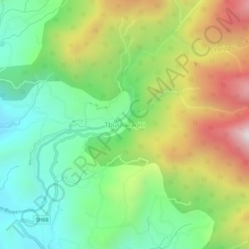
Name: Thusharagiri topographic map, elevation, terrain.
Location: Thusharagiri, Thamarassery, Kozhikode district, Kerala, India (11.45093 76.03203 11.49093 76.07203)
Average elevation: 542 m
Minimum elevation: 111 m
Maximum elevation: 1,231 m
Other topographic maps
Click on a map to view its topography, its elevation and its terrain.
Adivaram
India > Kerala > Thamarassery
Adivaram, Thamarassery, Kozhikode District, Kerala, 673586, India
Average elevation: 301 m
Malapuram
India > Kerala > Thamarassery > Engapuzha
Malapuram, Engapuzha, Thamarassery, Kozhikode District, Kerala, India
Average elevation: 54 m
Thiruvambady
India > Kerala > Thamarassery
Thiruvambady, Thamarassery, Kozhikode district, Kerala, 673603, India
Average elevation: 46 m
Kakkadampoyil
India > Kerala > Thamarassery
Kakkadampoyil, Thamarassery, Kozhikode district, Kerala, 673604, India
Average elevation: 616 m
Kodencherry
India > Kerala > Thamarassery > Kodencherry
Kodencherry, Thamarassery, Kozhikode district, Kerala, 673580, India
Average elevation: 65 m
Vavul Mala
India > Kerala > Thamarassery
Vavul Mala, Thamarassery, Kozhikode district, Kerala, India
Average elevation: 1,940 m
Thamarassery
India > Kerala > Thamarassery
Thamarassery, Kozhikode district, Kerala, 673573, India
Average elevation: 49 m