Geolocate

Pleasant Grove topographic map

Click on the map to display elevation.

About this map

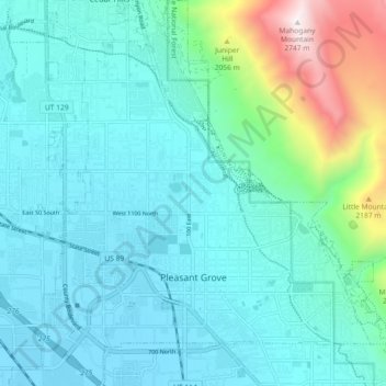
Name: Pleasant Grove topographic map, elevation, terrain.

Location: Pleasant Grove, Utah County, Utah, 84062, United States (40.34450 -111.77416 40.41383 -111.69623)

Average elevation: 1,578 m

Minimum elevation: 1,371 m

Maximum elevation: 2,738 m

Other topographic maps

Click on a map to view its topography, its elevation and its terrain.

Spanish Fork Peak

United States > Utah > Utah County

Average elevation: 2,720 m

Mount Timpanogos

United States > Utah > Utah County

Average elevation: 3,139 m

Bald Mountain Overlook

United States > Utah > Utah County

Average elevation: 2,552 m

Lone Peak

United States > Utah > Utah County

Average elevation: 3,013 m

Curtis

United States > Utah > Utah County > Orem

Average elevation: 1,433 m

Birdseye

United States > Utah > Utah County

Average elevation: 1,780 m

Nutty Putty Cave

United States > Utah > Utah County

Average elevation: 1,547 m

Mount Timpanogos

United States > Utah > Utah County

Average elevation: 3,139 m

Caryhurst

United States > Utah > Utah County > Provo

Average elevation: 1,563 m

Pleasant View

United States > Utah > Utah County > Provo

Average elevation: 1,446 m

Townsend

United States > Utah > Utah County > Genola

Average elevation: 1,438 m

Lone Peak

United States > Utah > Utah County

Average elevation: 3,013 m

Gear up for your next adventure:

📱Phone Mounts for Hiking - Secure mounts to carry your phone on trails
📐Altimeters & Barometers - Tools for measuring altitude and air pressure
🔦LED Camping Lanterns - Illumination for reading maps inside your tent at night
🧘Folding Sit Mats - Dry and warm seat for map-reading breaks on damp ground
🌄Compact Monoculars - Lightweight optics for hiking

As an Amazon Associate, this site earns from qualifying purchases at no extra cost to you.