
Make a donation
Gear up for your next adventure:
As an Amazon Associate, this site earns from qualifying purchases at no extra cost to you.
Lubumbashi topographic map
Click on the map to display elevation.
Make a donation
Gear up for your next adventure:
As an Amazon Associate, this site earns from qualifying purchases at no extra cost to you.
Lubumbashi
Lubumbashi lies at around 1,208 m (3,963 ft) above sea level. The high altitude serves to cool the climate, which would otherwise be very hot. The Kafue River rises along the Zambian border near the city and meanders through north-central Zambia to the Zambezi River, cutting a long, deep panhandle into the country.
Make a donation
Gear up for your next adventure:
As an Amazon Associate, this site earns from qualifying purchases at no extra cost to you.
About this map
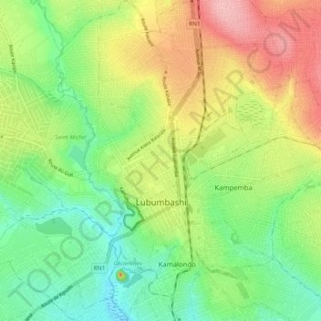
Name: Lubumbashi topographic map, elevation, terrain.
Average elevation: 1,249 m
Minimum elevation: 1,193 m
Maximum elevation: 1,329 m
Make a donation
Gear up for your next adventure:
As an Amazon Associate, this site earns from qualifying purchases at no extra cost to you.
Other topographic maps
Click on a map to view its topography, its elevation and its terrain.
Lubumbashi
Democratic Republic of the Congo > Haut-Katanga > Ville de Lubumbashi > Lubumbashi
Average elevation: 1,250 m