
Thank you for supporting this site ❤️
Make a donation
Make a donation
Gear up for your next adventure:
As an Amazon Associate, this site earns from qualifying purchases at no extra cost to you.
Karatagi topographic map
Click on the map to display elevation.
Thank you for supporting this site ❤️
Make a donation
Make a donation
Gear up for your next adventure:
As an Amazon Associate, this site earns from qualifying purchases at no extra cost to you.
About this map
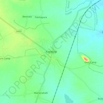
Name: Karatagi topographic map, elevation, terrain.
Location: Karatagi, Karatagi taluku, Koppal, Karnataka, 583229, India (15.56815 76.61882 15.64815 76.69882)
Average elevation: 422 m
Minimum elevation: 397 m
Maximum elevation: 497 m
Thank you for supporting this site ❤️
Make a donation
Make a donation
Gear up for your next adventure:
As an Amazon Associate, this site earns from qualifying purchases at no extra cost to you.