Geolocate

Neath topographic map

Click on the map to display elevation.

About this map

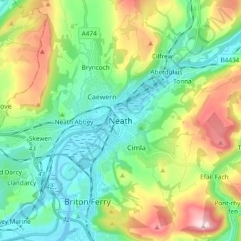
Name: Neath topographic map, elevation, terrain.

Location: Neath, Neath Port Talbot, Wales, SA11 1DY, United Kingdom (51.62284 -3.84391 51.70284 -3.76391)

Average elevation: 115 m

Minimum elevation: -4 m

Maximum elevation: 370 m

Neath Port Talbot trails, hiking, mountain biking, running and outdoor activities

Other topographic maps

Click on a map to view its topography, its elevation and its terrain.

Neath

United Kingdom > Wales > Neath Port Talbot

Average elevation: 71 m

Glynneath

United Kingdom > Wales > Neath Port Talbot

Average elevation: 246 m

Crynant

United Kingdom > Wales > Neath Port Talbot

Average elevation: 232 m

River Neath

United Kingdom > Wales > Neath Port Talbot > Resolven

Average elevation: 272 m

Cilybebyll

United Kingdom > Wales > Neath Port Talbot > Gellinudd

Average elevation: 179 m

Pelenna

United Kingdom > Wales > Neath Port Talbot

Average elevation: 217 m

Pontardawe

United Kingdom > Wales > Neath Port Talbot

Average elevation: 180 m

Gear up for your next adventure:

🧭Orienteering Compasses - Accurate compasses for map-based navigation
🧴Sport Sunscreen Sticks - High-protection sunblock that won't run into your eyes on the trail
🥤Hiking Water Bottles - Reusable bottles for hydration on the trail
🌦️Portable Weather Meters - Handheld tools for monitoring weather conditions
🥾Trekking Poles - Poles to improve stability on uneven terrain

As an Amazon Associate, this site earns from qualifying purchases at no extra cost to you.