Geolocate

Tapri topographic map

Click on the map to display elevation.

About this map

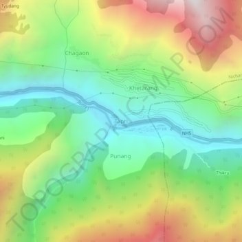
Name: Tapri topographic map, elevation, terrain.

Location: Tapri, Nichar, Kinnaur, Himachal Pradesh, 172104, India (31.49706 78.07747 31.53706 78.11747)

Average elevation: 2,312 m

Minimum elevation: 1,643 m

Maximum elevation: 3,369 m

Other topographic maps

Click on a map to view its topography, its elevation and its terrain.

Nathpa Jhakri Dam

India > Himachal Pradesh > Nichar > Nichar

Average elevation: 1,958 m

Gear up for your next adventure:

🥼Base Layers - Thermal base layers for temperature regulation
🔦Outdoor Torches - Reliable torches for night navigation
🧢Hiking Hats - Sun and weather protection for outdoor walks
🧥Waterproof Hiking Jackets - Rain protection for walking in all weather conditions
👖Hiking Trousers - Durable trousers designed for rough terrain

As an Amazon Associate, this site earns from qualifying purchases at no extra cost to you.