
Le Mas Neuf topographic map
Interactive map
Click on the map to display elevation.
About this map
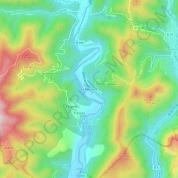
Name: Le Mas Neuf topographic map, elevation, terrain.
Average elevation: 327 m
Minimum elevation: 153 m
Maximum elevation: 631 m
Other topographic maps
Click on a map to view its topography, its elevation and its terrain.
Le Figaret
France > Occitanie > Gard > Saint-Julien-de-la-Nef
Le Figaret, Saint-Julien-de-la-Nef, Le Vigan, Gard, Occitanie, France métropolitaine, 30440, France
Average elevation: 348 m
Piécourt
France > Occitanie > Gard > Saint-Julien-de-la-Nef
Piécourt, Saint-Julien-de-la-Nef, Le Vigan, Gard, Occitanie, France métropolitaine, 30440, France
Average elevation: 340 m