
Rockbeare topographic map
Interactive map
Click on the map to display elevation.
About this map
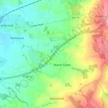
Name: Rockbeare topographic map, elevation, terrain.
Average elevation: 73 m
Minimum elevation: 21 m
Maximum elevation: 168 m
Other topographic maps
Click on a map to view its topography, its elevation and its terrain.
Allercombe
United Kingdom > England > Devon > East Devon > Marsh Green > Allercombe
Allercombe, Rockbeare, Marsh Green, East Devon, Devon, South West England, England, EX5 2PR, United Kingdom
Average elevation: 90 m
Marsh Green
United Kingdom > England > Devon > East Devon > Marsh Green
Marsh Green, East Devon, Devon, South West England, England, EX5 2ET, United Kingdom
Average elevation: 83 m