
Make a donation
Gear up for your next adventure:
As an Amazon Associate, this site earns from qualifying purchases at no extra cost to you.
Palm Harbor topographic map
Click on the map to display elevation.
Make a donation
Gear up for your next adventure:
As an Amazon Associate, this site earns from qualifying purchases at no extra cost to you.
About this map
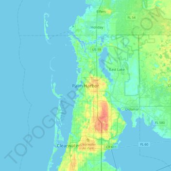
Name: Palm Harbor topographic map, elevation, terrain.
Location: Palm Harbor, Pinellas County, Florida, 34683, United States (28.03807 -82.80371 28.11807 -82.72371)
Average elevation: 9 m
Minimum elevation: -2 m
Maximum elevation: 32 m
Make a donation
Gear up for your next adventure:
As an Amazon Associate, this site earns from qualifying purchases at no extra cost to you.
Other topographic maps
Click on a map to view its topography, its elevation and its terrain.
Saint Petersburg
United States > Florida > Pinellas County
Saint Petersburg features a predominantly flat topography characteristic of the Gulf Coast region. The city's elevation averages around 44 feet (approximately 13.4 meters) above sea level, with some areas dipping to about 15 feet (4.6 meters). This relatively low elevation contributes to the area's…
Average elevation: 4 m
Tarpon Springs
United States > Florida > Pinellas County
Tarpon Springs features a low-lying coastal terrain typical of the Gulf Coast region. The area rests just a few feet above sea level, with elevations averaging around 13-29 feet, and much of the city is flat or gently sloping toward the Gulf of Mexico. This topography is shaped by its proximity to bodies of…
Average elevation: 5 m
Clearwater
United States > Florida > Pinellas County
Clearwater, situated on the western coast of Florida, features a relatively flat topography typical of the Gulf Coast region. The city lies at an average elevation of around 30 feet above sea level, characterized by gently rolling terrain that transitions smoothly into the expansive beaches along the Gulf of…
Average elevation: 8 m
Dunedin
United States > Florida > Pinellas County
Dunedin is characterized by a predominantly flat terrain, with an average elevation of approximately 13 feet (4 meters) above sea level, making it typical of the coastal regions of Pinellas County. The area's topography is defined by its proximity to the Gulf of Mexico, which influences its gently rolling…
Average elevation: 11 m
Make a donation
Gear up for your next adventure:
As an Amazon Associate, this site earns from qualifying purchases at no extra cost to you.
Pinellas Park
United States > Florida > Pinellas County
Pinellas Park, located in Pinellas County, Florida, features relatively flat terrain characteristic of the broader region. Situated on the Pinellas Peninsula, the city is part of an area that is only a few feet above sea level. The landscape includes low-lying wetlands, coastal marshes, and several small…
Average elevation: 7 m
Seminole
United States > Florida > Pinellas County
Seminole features predominantly flat terrain with an average elevation of approximately 36 feet (11 meters) above sea level. The area is characterized by its proximity to the Gulf of Mexico, which significantly influences its landscape and climate. Surrounding Seminole are a mix of residential…
Average elevation: 9 m
Oldsmar
United States > Florida > Pinellas County
Oldsmar features a gently rolling terrain characterized by a mix of low-lying wetlands and elevated areas. The city sits at an average elevation of about 20 feet above sea level, providing it with a unique vantage point over the surrounding landscapes. Its proximity to Tampa Bay influences the topography, with…
Average elevation: 6 m
Largo
United States > Florida > Pinellas County
In 2010, Largo's total area was 18.6 square miles (48.1 km2), of which 17.6 square miles (45.6 km2) was land and 0.97 square miles (2.5 km2), or 5.22%, was water. As of 2004, there were 651 acres (2.6 km2) of park lands. The city's lowest elevation is sea level. At its highest, the city's elevation is about 69…
Average elevation: 9 m
Make a donation
Gear up for your next adventure:
As an Amazon Associate, this site earns from qualifying purchases at no extra cost to you.
Make a donation
Gear up for your next adventure:
As an Amazon Associate, this site earns from qualifying purchases at no extra cost to you.
Treasure Island
United States > Florida > Pinellas County
With an elevation of only three feet, the Great Gale of 1848 carved out John's Pass on the island's north end and split off two smaller islands, called the Isle of Palms and Isle of Capri.
Average elevation: 2 m
Make a donation
Gear up for your next adventure:
As an Amazon Associate, this site earns from qualifying purchases at no extra cost to you.
Fort De Soto County Park
United States > Florida > Pinellas County > Saint Petersburg
Average elevation: 0 m
Largo
United States > Florida > Pinellas County
In 2010, Largo's total area was 18.6 square miles (48.1 km2), of which 17.6 square miles (45.6 km2) was land and 0.97 square miles (2.5 km2), or 5.22%, was water. As of 2004, there were 651 acres (2.6 km2) of park lands. The city's lowest elevation is sea level. At its highest, the city's elevation is about 69…
Average elevation: 9 m
Make a donation
Gear up for your next adventure:
As an Amazon Associate, this site earns from qualifying purchases at no extra cost to you.
Make a donation
Gear up for your next adventure:
As an Amazon Associate, this site earns from qualifying purchases at no extra cost to you.
Largo
United States > Florida > Pinellas County
In 2010, Largo's total area was 18.6 square miles (48.1 km2), of which 17.6 square miles (45.6 km2) was land and 0.97 square miles (2.5 km2), or 5.22%, was water. As of 2004, there were 651 acres (2.6 km2) of park lands. The city's lowest elevation is sea level. At its highest, the city's elevation is about 69…
Average elevation: 9 m
Make a donation
Gear up for your next adventure:
As an Amazon Associate, this site earns from qualifying purchases at no extra cost to you.
Make a donation
Gear up for your next adventure:
As an Amazon Associate, this site earns from qualifying purchases at no extra cost to you.
Make a donation
Gear up for your next adventure:
As an Amazon Associate, this site earns from qualifying purchases at no extra cost to you.
Make a donation
Gear up for your next adventure:
As an Amazon Associate, this site earns from qualifying purchases at no extra cost to you.
Boyd Hill Nature Preserve
United States > Florida > Pinellas County > Saint Petersburg > Lakewood Estates
Average elevation: 7 m
Make a donation
Gear up for your next adventure:
As an Amazon Associate, this site earns from qualifying purchases at no extra cost to you.
Make a donation
Gear up for your next adventure:
As an Amazon Associate, this site earns from qualifying purchases at no extra cost to you.
Make a donation
Gear up for your next adventure:
As an Amazon Associate, this site earns from qualifying purchases at no extra cost to you.
Boyd Hill Nature Preserve
United States > Florida > Pinellas County > Saint Petersburg > Lakewood Estates
Average elevation: 7 m
Oldsmar
United States > Florida > Pinellas County
In 1921, a hurricane hit Tampa Bay. Because Oldsmar sits on a plateau with an elevation never rising over 20 feet (6.1 m) above sea level, it was devastated by the storm. Large trees were uprooted and floodwater reached levels 14 feet (4.3 m) above normal. Some of the homes that survived the storm were moved,…
Average elevation: 6 m
Make a donation
Gear up for your next adventure:
As an Amazon Associate, this site earns from qualifying purchases at no extra cost to you.
Redington Shores
United States > Florida > Pinellas County
According to the United States Census Bureau, the town has a total area of 1.2 square miles (3.1 km2), of which 0.4 square miles (1.0 km2) is land and 0.8 square miles (2.1 km2) (67.50%) is water. According to Elevation Map Logs, the elevation of Redington Shores is just one meter above sea level.
Average elevation: 2 m
Make a donation
Gear up for your next adventure:
As an Amazon Associate, this site earns from qualifying purchases at no extra cost to you.
Pinellas Park
United States > Florida > Pinellas County
Because of the city's relatively low elevation between major bodies of water, and its generally flat topography, it has historically been subject to flooding. Through construction of a network of drainage canals and other measures by the Pinellas Park Water Management District, flooding in the city has been…
Average elevation: 7 m
Oldsmar
United States > Florida > Pinellas County
The city sits on a plateau with an elevation never rising over 20 feet (6.1 m) above sea level. In 1921, the town was hit by a devastating hurricane. Large pine trees were uprooted and most of the town was flooded by water reaching levels 14 feet (4.3 m) above normal. Some of the city's oldest homes remain on…
Average elevation: 6 m
Make a donation
Gear up for your next adventure:
As an Amazon Associate, this site earns from qualifying purchases at no extra cost to you.
Oldsmar
United States > Florida > Pinellas County
In 1921, a hurricane hit Tampa Bay. Because Oldsmar sits on a plateau with an elevation never rising over 20 feet (6.1 m) above sea level, it was devastated by the storm. Large trees were uprooted and floodwater reached levels 14 feet (4.3 m) above normal. Some of the homes that survived the storm were moved,…
Average elevation: 6 m
Make a donation
Gear up for your next adventure:
As an Amazon Associate, this site earns from qualifying purchases at no extra cost to you.
Pinellas Park
United States > Florida > Pinellas County
Because of the city's relatively low elevation between major bodies of water, and its generally flat topography, it has historically been subject to flooding. Through construction of a network of drainage canals and other measures by the Pinellas Park Water Management District, flooding in the city has been…
Average elevation: 7 m
Make a donation
Gear up for your next adventure:
As an Amazon Associate, this site earns from qualifying purchases at no extra cost to you.
Treasure Island
United States > Florida > Pinellas County
With an elevation of only three feet, the Great Gale of 1848 carved out John's Pass on the island's north end and split off two smaller islands, called the Isle of Palms and Isle of Capri.
Average elevation: 2 m
Make a donation
Gear up for your next adventure:
As an Amazon Associate, this site earns from qualifying purchases at no extra cost to you.
Make a donation
Gear up for your next adventure:
As an Amazon Associate, this site earns from qualifying purchases at no extra cost to you.
Pinellas Park
United States > Florida > Pinellas County
Because of the city's relatively low elevation between major bodies of water, and its generally flat topography, it has historically been subject to flooding. Through construction of a network of drainage canals and other measures by the Pinellas Park Water Management District, flooding in the city has been…
Average elevation: 7 m