
Thank you for supporting this site ❤️
Make a donation
Make a donation
Gear up for your next adventure:
As an Amazon Associate, this site earns from qualifying purchases at no extra cost to you.
Ankazobe topographic map
Click on the map to display elevation.
Thank you for supporting this site ❤️
Make a donation
Make a donation
Gear up for your next adventure:
As an Amazon Associate, this site earns from qualifying purchases at no extra cost to you.
About this map
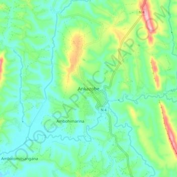
Name: Ankazobe topographic map, elevation, terrain.
Location: Ankazobe, Analamanga, Province d’Antananarivo, Madagascar (-18.35437 47.07452 -18.27437 47.15452)
Average elevation: 1,222 m
Minimum elevation: 1,166 m
Maximum elevation: 1,379 m
Thank you for supporting this site ❤️
Make a donation
Make a donation
Gear up for your next adventure:
As an Amazon Associate, this site earns from qualifying purchases at no extra cost to you.