
Herðubreið topographic map
Interactive map
Click on the map to display elevation.
About this map
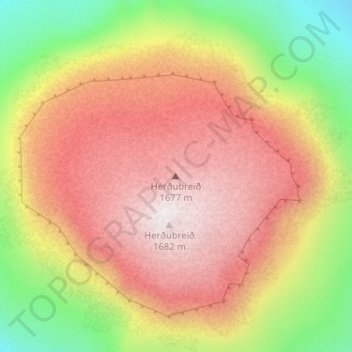
Name: Herðubreið topographic map, elevation, terrain.
Location: Herðubreið, Þingeyjarsveit, Northeastern Region, Iceland (65.17863 -16.34507 65.17873 -16.34497)
Average elevation: 1,191 m
Minimum elevation: 653 m
Maximum elevation: 1,641 m
Other topographic maps
Click on a map to view its topography, its elevation and its terrain.
Laugar
Laugar, Þingeyjarsveit, Northeastern Region, 650, Iceland
Average elevation: 155 m
Mývatn
Iceland > Þingeyjarsveit > Reykjahlíð
Mývatn, Reykjahlíð, Þingeyjarsveit, Northeastern Region, Iceland
Average elevation: 285 m
Reykjahlíð
Reykjahlíð, Þingeyjarsveit, Northeastern Region, Iceland
Average elevation: 305 m