Geolocate

Tashkent topographic map

Click on the map to display elevation.

About this map

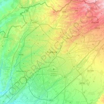
Name: Tashkent topographic map, elevation, terrain.

Location: Tashkent, Yakkasaroy Tumani, Tashkent, 100128, Uzbekistan (41.15234 69.11871 41.47234 69.43871)

Average elevation: 447 m

Minimum elevation: 352 m

Maximum elevation: 629 m

Other topographic maps

Click on a map to view its topography, its elevation and its terrain.

Uchtepa Tumani

Uzbekistan > Tashkent

Average elevation: 417 m

Mirzo Ulugbek district

Uzbekistan > Tashkent

Average elevation: 490 m

Shayhontohur Tumani

Uzbekistan > Tashkent

Average elevation: 434 m

Sirgali district

Uzbekistan > Tashkent

Average elevation: 410 m

Bektemir district

Uzbekistan > Tashkent

Average elevation: 424 m

Gear up for your next adventure:

🧥Packable Down Jackets - Lightweight warmth that compresses small in your bag
🔥Emergency Fire Starters - Reliable ignition tools for survival situations in damp conditions
👟Women's Trail Running Shoes - Agile footwear for fell running and technical trails
🧼Technical Clothing Wash - Special soap to clean and restore waterproof membranes
📻Hand-Crank Emergency Radios - Stay updated on weather warnings in remote areas

As an Amazon Associate, this site earns from qualifying purchases at no extra cost to you.