
Make a donation
Gear up for your next adventure:
As an Amazon Associate, this site earns from qualifying purchases at no extra cost to you.
Windham County topographic map
Click on the map to display elevation.
Make a donation
Gear up for your next adventure:
As an Amazon Associate, this site earns from qualifying purchases at no extra cost to you.
About this map
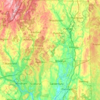
Name: Windham County topographic map, elevation, terrain.
Average elevation: 156 m
Minimum elevation: 28 m
Maximum elevation: 398 m
Make a donation
Gear up for your next adventure:
As an Amazon Associate, this site earns from qualifying purchases at no extra cost to you.
Other topographic maps
Click on a map to view its topography, its elevation and its terrain.
Killingly Center
United States > Connecticut > Northeastern Connecticut Planning Region > Killingly > Dayville
Average elevation: 109 m
Central Village
United States > Connecticut > Northeastern Connecticut Planning Region > Plainfield
Average elevation: 69 m
Elmville
United States > Connecticut > Northeastern Connecticut Planning Region > Killingly
Average elevation: 106 m