
Moreno Valley topographic map
Interactive map
Click on the map to display elevation.
About this map
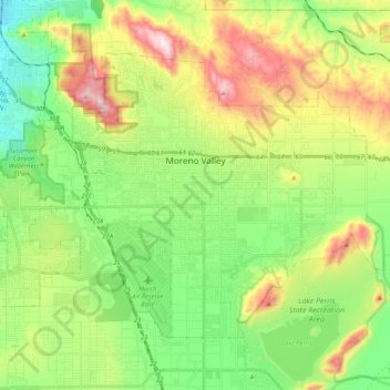
Name: Moreno Valley topographic map, elevation, terrain.
Average elevation: 527 m
Minimum elevation: 291 m
Maximum elevation: 941 m
Other topographic maps
Click on a map to view its topography, its elevation and its terrain.
Sunnymead
United States of America > California > Moreno Valley > Sunnymead
Sunnymead, Moreno Valley, Riverside County, California, 92553, United States of America
Average elevation: 511 m
Serrano Heights
United States of America > California > Moreno Valley > Serrano Heights
Serrano Heights, Moreno Valley, Riverside County, California, United States of America
Average elevation: 640 m