Geolocate

Gympie topographic map

Click on the map to display elevation.

About this map

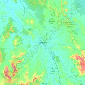
Name: Gympie topographic map, elevation, terrain.

Location: Gympie, Gympie Regional, Queensland, Australia (-26.35004 152.50003 -26.03004 152.82003)

Average elevation: 124 m

Minimum elevation: 28 m

Maximum elevation: 599 m

Other topographic maps

Click on a map to view its topography, its elevation and its terrain.

Lake Borumba

Australia > Queensland > Gympie

Average elevation: 257 m

Queens Park

Australia > Queensland > Gympie

Average elevation: 63 m

Gear up for your next adventure:

🎒Backpack Rain Covers - Universal waterproof covers to protect your gear from downpours
🧰Survival Kits - Emergency tools for remote environments
🗺️Topographic Maps - Detailed maps showing elevation and terrain features
👟Men's Trail Running Shoes - Lightweight grip for fast movement over topographic contours
🧵Survival Paracord - Multi-purpose cordage for emergency repairs and shelters

As an Amazon Associate, this site earns from qualifying purchases at no extra cost to you.