
Millingen aan de Rijn topographic map
Interactive map
Click on the map to display elevation.
About this map
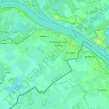
Name: Millingen aan de Rijn topographic map, elevation, terrain.
Location: Millingen aan de Rijn, Berg en Dal, Gelderland, Nederland (51.83720 5.98575 51.88167 6.06349)
Average elevation: 12 m
Minimum elevation: 7 m
Maximum elevation: 21 m
Other topographic maps
Click on a map to view its topography, its elevation and its terrain.
Duivelsberg
Nederland > Gelderland > Berg en Dal
Duivelsberg, Berg en Dal, Gelderland, Nederland, 6572BE, Nederland
Average elevation: 31 m