
Thank you for supporting this site ❤️
Make a donation
Make a donation
Gear up for your next adventure:
As an Amazon Associate, this site earns from qualifying purchases at no extra cost to you.
Ritterhude topographic map
Click on the map to display elevation.
Thank you for supporting this site ❤️
Make a donation
Make a donation
Gear up for your next adventure:
As an Amazon Associate, this site earns from qualifying purchases at no extra cost to you.
About this map
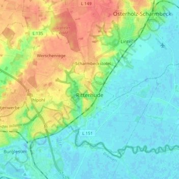
Name: Ritterhude topographic map, elevation, terrain.
Location: Ritterhude, Landkreis Osterholz, Lower Saxony, 27721, Germany (53.15820 8.66226 53.22393 8.80782)
Average elevation: 16 m
Minimum elevation: -2 m
Maximum elevation: 50 m
Thank you for supporting this site ❤️
Make a donation
Make a donation
Gear up for your next adventure:
As an Amazon Associate, this site earns from qualifying purchases at no extra cost to you.