
Thank you for supporting this site ❤️
Make a donation
Make a donation
Gear up for your next adventure:
As an Amazon Associate, this site earns from qualifying purchases at no extra cost to you.
Valinouët topographic map
Click on the map to display elevation.
Thank you for supporting this site ❤️
Make a donation
Make a donation
Gear up for your next adventure:
As an Amazon Associate, this site earns from qualifying purchases at no extra cost to you.
About this map
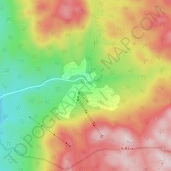
Name: Valinouët topographic map, elevation, terrain.
Average elevation: 600 m
Minimum elevation: 385 m
Maximum elevation: 814 m
Thank you for supporting this site ❤️
Make a donation
Make a donation
Gear up for your next adventure:
As an Amazon Associate, this site earns from qualifying purchases at no extra cost to you.
Other topographic maps
Click on a map to view its topography, its elevation and its terrain.
Lac à la Ligne
Canada > Québec > Le Fjord-du-Saguenay > Saint-David-de-Falardeau
Average elevation: 191 m
Lac Brochet
Canada > Québec > Le Fjord-du-Saguenay > Saint-David-de-Falardeau
Average elevation: 214 m