
Thank you for supporting this site ❤️
Make a donation
Make a donation
Gear up for your next adventure:
As an Amazon Associate, this site earns from qualifying purchases at no extra cost to you.
Guímara topographic map
Click on the map to display elevation.
Thank you for supporting this site ❤️
Make a donation
Make a donation
Gear up for your next adventure:
As an Amazon Associate, this site earns from qualifying purchases at no extra cost to you.
About this map
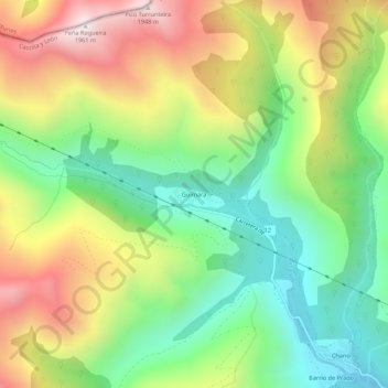
Name: Guímara topographic map, elevation, terrain.
Location: Guímara, Peranzanes, El Bierzo, León, Castile and León, Spain (42.87930 -6.70969 42.91930 -6.66969)
Average elevation: 1,370 m
Minimum elevation: 956 m
Maximum elevation: 1,948 m
Thank you for supporting this site ❤️
Make a donation
Make a donation
Gear up for your next adventure:
As an Amazon Associate, this site earns from qualifying purchases at no extra cost to you.