Geolocate

Loch Buidhe topographic map

Click on the map to display elevation.

About this map

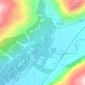
Name: Loch Buidhe topographic map, elevation, terrain.

Location: Loch Buidhe, Coulags, Highland, Scotland, United Kingdom (57.44500 -5.41470 57.44577 -5.41309)

Average elevation: 92 m

Minimum elevation: 4 m

Maximum elevation: 347 m

Highland trails, hiking, mountain biking, running and outdoor activities

Gear up for your next adventure:

👖Packable Overtrousers - Quick-deploy rain protection for legs in sudden storms
🥾Hiking Boots - Waterproof and durable boots for long-distance hiking in the UK
🚲Cycling GPS Computers - Track elevation and topographic routes on two wheels
🎒Hiking Daypacks (20L) - Compact backpacks for day trips and technical mountain ascents
🔦Head Torches - Hands-free lighting for hiking and camping

As an Amazon Associate, this site earns from qualifying purchases at no extra cost to you.