Geolocate

Franklin County topographic map

Interactive map

Click on the map to display elevation.

About this map

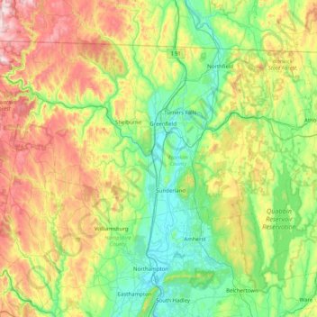
Name: Franklin County topographic map, elevation, terrain.

Location: Franklin County, Massachusetts, United States (42.30328 -73.02371 42.74114 -72.22493)

Average elevation: 270 m

Minimum elevation: 28 m

Maximum elevation: 806 m

Other topographic maps

Click on a map to view its topography, its elevation and its terrain.

Boston

United States > Massachusetts > Suffolk County

Boston has an area of 89.63 sq mi (232.1 km2)—48.4 sq mi (125.4 km2) (54%) of land and41.2 sq mi (106.7 km2) (46%) of water. The city's official elevation, as measured at Logan International Airport, is 19 ft (5.8 m) above sea level. The highest point in Boston is Bellevue Hill at 330 ft (100 m) above sea…

Average elevation: 25 m

Somerville

United States > Massachusetts > Middlesex County

Somerville's commercial property is not concentrated in a recognized downtown central business district but instead is spread over many different nodes or corridors of business activity. The difference in character ranges from the vibrant nightlife, live music and theaters of Davis Square to the large scale…

Average elevation: 11 m

Cape Cod

United States > Massachusetts > Barnstable County

Cape Cod extends 65 miles (105 km) into the Atlantic Ocean, with a breadth of between 1–20 miles (1.6–32.2 km), and covers more than 400 miles (640 km) of shoreline. Its elevation ranges from 306 feet (93 m) at its highest point, at the top of Pine Hill, in the Bourne portion of Joint Base Cape Cod, down…

Average elevation: 2 m

Worcester

United States > Massachusetts > Worcester County

Worcester is known for being particularly snowy in the cold months, sometimes even experiencing autumn blizzards. The city averages 48.1 inches (1,220 mm) of precipitation a year, as well as an average of 72.9 inches (185 cm) of snowfall a season, receiving far more snow than coastal locations less than 40…

Average elevation: 186 m

New Bedford

United States > Massachusetts > Bristol County

New Bedford is located at 41°39′06″N 70°56′01″W / 41.651803°N 70.933705°W / 41.651803; -70.933705 (41.651803, −70.933705). According to the United States Census Bureau, the city has a total area of 24.1 square miles (62.5 km2). Of the total area, 20.0 square miles (51.8 km2) is land, and…

Average elevation: 21 m

Boston

United States > Massachusetts > Suffolk County > Boston

Boston has an area of 89.63 sq mi (232.1 km2)—48.4 sq mi (125.4 km2) (54%) of land and41.2 sq mi (106.7 km2) (46%) of water. The city's official elevation, as measured at Logan International Airport, is 19 ft (5.8 m) above sea level. The highest point in Boston is Bellevue Hill at 330 ft (100 m) above sea…

Average elevation: 26 m

Arlington

United States > Massachusetts > Middlesex County

Arlington covers 3,517.5 acres (14 km2), or 5.5 square miles, of which 286.2 acres (1.2 km2), or 0.4 square miles, are covered by water. There are 210.52 acres (0.9 km2) of parkland. Elevation ranges from 4 feet (1.2 m) above sea level (along Alewife Brook) to 377 feet (114.9 m) near Park Avenue and Eastern…

Average elevation: 35 m

Beverly

United States > Massachusetts > Essex County > Beverly

Average elevation: 17 m

Berkshire County

United States > Massachusetts

Running north-south through the county are the Hoosac Range of the Berkshire Hills in the eastern part of the county and the Taconic Mountains in the western part of the county. Due to their elevation, the Berkshires attract tourists and summer residents eager to escape the heat of the lowlands.

Average elevation: 359 m

Barnstable County

United States > Massachusetts

The highest elevation in the county is 306 feet (93 m) on the summit of Pine Hill, located on Joint Base Cape Cod in Bourne. The lowest point is sea level.

Average elevation: 7 m

Cambridge

United States > Massachusetts > Middlesex County

Cambridge obtains water from Hobbs Brook (in Lincoln and Waltham) and Stony Brook (Waltham and Weston), as well as an emergency connection to the Massachusetts Water Resources Authority. The city owns over 1,200 acres (486 ha) of land in other towns that includes these reservoirs and portions of their…

Average elevation: 11 m

Natick

United States > Massachusetts > Middlesex County

Average elevation: 55 m

Newton

United States > Massachusetts > Middlesex County

Geologically Newton located within topographic lowland the Boston Basin of the Appalachian Mountain chain.This lowland is surrounded by a ring of highland drumlins which were left after the last glaciation twelve thousand years ago.

Average elevation: 38 m

Pittsfield

United States > Massachusetts > Berkshire County

Pittsfield has a humid continental climate (Dfb). Winters are harsh due the city's high elevation at 1,039 ft (317 m), with an average annual snowfall of 75.9 inches (1,930 mm) and temperatures dipping to 0 °F (−18 °C) or colder 13 times per year. Summers, however, are typically warm and pleasant, with…

Average elevation: 369 m

Cape Cod Bay

United States > Massachusetts

The Cape's lifeline is groundwater. Rain and melting snow swiftly sink into the sandy soils, where it pools to form a massive subterranean groundwater reservoir beneath the majority of the Cape. Groundwater continues to flow into and out of ponds, feeding streams, and flowing towards the coast, finding sea…

Average elevation: 0 m

Pittsfield

United States > Massachusetts > Berkshire County

Pittsfield has a humid continental climate (Dfb). Winters are harsh due the city's high elevation at 1,039 ft (317 m), with an average annual snowfall of 75.9 inches (1,930 mm) and temperatures dipping to 0 °F (−18 °C) or colder 13 times per year. Summers, however, are typically warm and pleasant, with…

Average elevation: 433 m

Fall River

United States > Massachusetts > Bristol County

Fall River was the only city on the East Coast of the United States to have had an exposed waterfall in part of its downtown area; it flowed less than 1⁄2 mile (0.8 km) into a sheltered harbor at the edge of downtown. Fall River has two large lakes (originally one lake) and a large portion of protected…

Average elevation: 32 m

Menemsha

United States > Massachusetts > Dukes County

Average elevation: 14 m

Belmont

United States > Massachusetts > Middlesex County

Belmont has been referred to as a "Mormon enclave" due to the location of the Boston Massachusetts Temple of the LDS Church at the highest elevation in the town. The prominent gold statue of the Angel Moroni atop the Temple was originally designed by Cyrus Dallin in nearby Arlington, Massachusetts.

Average elevation: 40 m

Uxbridge

United States > Massachusetts > Worcester County

The town is 30.4 square miles (79 km2), of which 0.8 square miles (2.1 km2), or 2.74%, is water. It is situated 39.77 miles (64.00 km) southwest of Boston, 16 miles (26 km) southeast of Worcester, and 20 miles (32 km) northwest of Providence. Elevations range from 200 feet (61 m) to 577 feet (176 m) above sea…

Average elevation: 115 m

Gardner

United States > Massachusetts > Worcester County

According to the United States Census Bureau, Gardner has a total area of 23.0 square miles (60 km2), of which 22.2 square miles (57 km2) is land and 0.8 square miles (2.1 km2), or 3.52%, is water. The city is situated on Crystal Lake. Its highest point is the summit of Reservoir Hill, close to the city…

Average elevation: 326 m

Raynham

United States > Massachusetts > Bristol County

Average elevation: 18 m