
Make a donation
Gear up for your next adventure:
As an Amazon Associate, this site earns from qualifying purchases at no extra cost to you.
Loch Humphrey topographic map
Click on the map to display elevation.
Make a donation
Gear up for your next adventure:
As an Amazon Associate, this site earns from qualifying purchases at no extra cost to you.
About this map
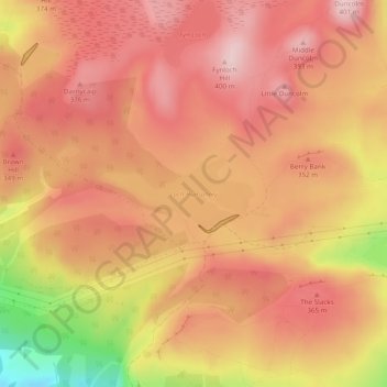
Name: Loch Humphrey topographic map, elevation, terrain.
Location: Loch Humphrey, West Dunbartonshire, Scotland, United Kingdom (55.94962 -4.48270 55.95478 -4.46330)
Average elevation: 320 m
Minimum elevation: 149 m
Maximum elevation: 397 m
West Dunbartonshire trails, hiking, mountain biking, running and outdoor activities
Make a donation
Gear up for your next adventure:
As an Amazon Associate, this site earns from qualifying purchases at no extra cost to you.
Other topographic maps
Click on a map to view its topography, its elevation and its terrain.
Make a donation
Gear up for your next adventure:
As an Amazon Associate, this site earns from qualifying purchases at no extra cost to you.
Tulliechewan Farm
United Kingdom > Scotland > West Dunbartonshire > Alexandria
Average elevation: 102 m
Make a donation
Gear up for your next adventure:
As an Amazon Associate, this site earns from qualifying purchases at no extra cost to you.
Make a donation
Gear up for your next adventure:
As an Amazon Associate, this site earns from qualifying purchases at no extra cost to you.