
Make a donation
Gear up for your next adventure:
As an Amazon Associate, this site earns from qualifying purchases at no extra cost to you.
Lake Toma topographic map
Click on the map to display elevation.
Make a donation
Gear up for your next adventure:
As an Amazon Associate, this site earns from qualifying purchases at no extra cost to you.
About this map
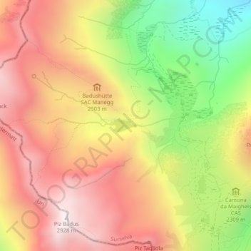
Name: Lake Toma topographic map, elevation, terrain.
Location: Lake Toma, Tujetsch, Surselva, Grisons, Switzerland (46.63176 8.67029 46.63309 8.67473)
Average elevation: 2,390 m
Minimum elevation: 1,753 m
Maximum elevation: 2,887 m
Make a donation
Gear up for your next adventure:
As an Amazon Associate, this site earns from qualifying purchases at no extra cost to you.
Other topographic maps
Click on a map to view its topography, its elevation and its terrain.
Rheinquelle
Switzerland > Grisons > Surselva > Tujetsch
The Swiss Federal Office of Topography and ETH Zürich indicate a point north of Lake Toma and the Rein da Tuma as the source of the Rhine (and also of the Vorderrhein), and as the source of the Hinterrhein a point in the upper valley of the Rheinwald, east of the Rheinwaldhorn.
Average elevation: 2,435 m