Geolocate

Dacudao topographic map

Click on the map to display elevation.

About this map

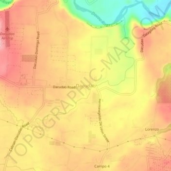
Name: Dacudao topographic map, elevation, terrain.

Location: Dacudao, Davao City, Davao Region, 8018, Philippines (7.19549 125.45568 7.23549 125.49568)

Average elevation: 182 m

Minimum elevation: 82 m

Maximum elevation: 242 m

Other topographic maps

Click on a map to view its topography, its elevation and its terrain.

Matina Aplaya

Philippines > Davao City

Average elevation: 3 m

Lapu-Lapu

Philippines > Davao City

Average elevation: 5 m

Salaysay

Philippines > Davao City

Average elevation: 809 m

26-C Silangan

Philippines > Davao City

Average elevation: 4 m

Matina Pangi

Philippines > Davao City

Average elevation: 53 m

Baganihan

Philippines > Davao City

Average elevation: 1,106 m

Marilog

Philippines > Davao City

Average elevation: 600 m

Gear up for your next adventure:

🥾Hiking Boot Waterproofing Wax - Maintain the lifespan of your leather trekking boots
🥾Walking Shoes - Lightweight walking shoes for countryside and coastal paths
🔥Reusable Hand Warmers - Maintain dexterity in your fingers for precise map handling
🛰️Handheld GPS Devices - Reliable GPS units for hiking and outdoor navigation
🔦Head Torches - Hands-free lighting for hiking and camping

As an Amazon Associate, this site earns from qualifying purchases at no extra cost to you.