Geolocate

Peacehaven topographic map

Click on the map to display elevation.

About this map

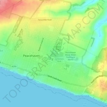
Name: Peacehaven topographic map, elevation, terrain.

Location: Peacehaven, Lewes, East Sussex, England, United Kingdom (50.78217 -0.01335 50.81152 0.03130)

Average elevation: 40 m

Minimum elevation: 0 m

Maximum elevation: 115 m

East Sussex trails, hiking, mountain biking, running and outdoor activities

Other topographic maps

Click on a map to view its topography, its elevation and its terrain.

BN10 8NG

United Kingdom > England > East Sussex > Peacehaven

Average elevation: 23 m

Gear up for your next adventure:

🛑Emergency Bivvy Bags - Heat-reflective survival bags for unexpected nights out
📦Compression Sacks - Reduce backpack volume efficiently
🚲Bikepacking Frame Bags - Storage for tools and navigation gear on long off-road rides
💧Hydration Reservoirs - Convenient water bladders for hands-free drinking on the move
🖼️Topographic Map Art - Decorative 3D-effect posters of famous UK peaks and regions

As an Amazon Associate, this site earns from qualifying purchases at no extra cost to you.