Geolocate

Muling topographic map

Click on the map to display elevation.

About this map

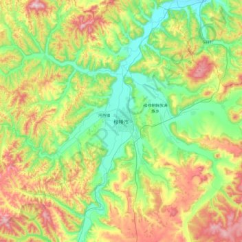
Name: Muling topographic map, elevation, terrain.

Location: Muling, Muling City, Mudanjiang City, Heilongjiang, China (44.75704 130.35721 45.07704 130.67721)

Average elevation: 404 m

Minimum elevation: 233 m

Maximum elevation: 711 m

Gear up for your next adventure:

🧦Merino Wool Hiking Socks - Moisture-wicking socks to prevent blisters during long mountain walks
💧Hydration Reservoirs - Convenient water bladders for hands-free drinking on the move
🔋Solar Chargers - Eco-friendly charging solutions for outdoor use
🛌Sleeping Bags - Warm and packable sleeping bags for outdoor nights
📱Rugged Phone Cases - Heavy-duty protection for smartphones used as secondary GPS tools

As an Amazon Associate, this site earns from qualifying purchases at no extra cost to you.