
Sibbertoft topographic map
Click on the map to display elevation.
About this map
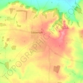
Name: Sibbertoft topographic map, elevation, terrain.
Location: Sibbertoft, West Northamptonshire, England, United Kingdom (52.41790 -1.03723 52.44874 -0.97472)
Average elevation: 156 m
Minimum elevation: 108 m
Maximum elevation: 190 m
West Northamptonshire trails, hiking, mountain biking, running and outdoor activities
Other topographic maps
Click on a map to view its topography, its elevation and its terrain.
Lower Thorpe
United Kingdom > England > West Northamptonshire > Thorpe Mandeville
Average elevation: 154 m
Ravensthorpe Reservoir
United Kingdom > England > West Northamptonshire > Coton
Average elevation: 131 m