Geolocate

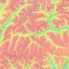
Hindu Raj topographic map

Click on the map to display elevation.

About this map

Name: Hindu Raj topographic map, elevation, terrain.

Location: Hindu Raj, Yasin Tehsil, Gupis-Yasin District, Gilgit Division, Gilgit-Baltistan, Pakistan (36.69995 73.14495 36.70005 73.14505)

Average elevation: 5,118 m

Minimum elevation: 4,504 m

Maximum elevation: 6,090 m

Other topographic maps

Click on a map to view its topography, its elevation and its terrain.
Gear up for your next adventure:

📦Compression Sacks - Reduce backpack volume efficiently
👟Waterproof Leg Gaiters - Keep mud and water out of your boots in boggy terrain
🚲Bikepacking Frame Bags - Storage for tools and navigation gear on long off-road rides
👖Hiking Trousers - Durable trousers designed for rough terrain
📷Camera Straps - Secure straps for carrying cameras while walking

As an Amazon Associate, this site earns from qualifying purchases at no extra cost to you.