Geolocate

Bera topographic map

Click on the map to display elevation.

About this map

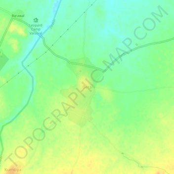
Name: Bera topographic map, elevation, terrain.

Location: Bera, Bali Tehsil, Pali District, Rajasthan, 306128, India (24.98119 73.15749 25.02119 73.19749)

Average elevation: 326 m

Minimum elevation: 312 m

Maximum elevation: 340 m

Gear up for your next adventure:

📱Phone Mounts for Hiking - Secure mounts to carry your phone on trails
🔋Solar Power Banks - Keep your GPS and phone charged during multi-day expeditions
📦Compression Sacks - Reduce backpack volume efficiently
🦯Walking Poles - Supportive poles for long-distance walking
🔦Outdoor Torches - Reliable torches for night navigation

As an Amazon Associate, this site earns from qualifying purchases at no extra cost to you.