
Marcinek topographic map
Interactive map
Click on the map to display elevation.
About this map
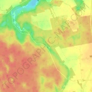
Name: Marcinek topographic map, elevation, terrain.
Average elevation: 90 m
Minimum elevation: 58 m
Maximum elevation: 107 m
Other topographic maps
Click on a map to view its topography, its elevation and its terrain.
Chodzież
Poland > Greater Poland Voivodeship > Chodzież County
Five kilometers west of Chodzież, at the edge of the Chodzieskie lakelands, Mt. Gontyniec rises 192 meters above sea level as the highest peak in a chain of moraine hills; at the same time it has the highest elevation in northern Poland. Deep valleys and ridges covered with a 100-year-old beech forest ensure…
Average elevation: 79 m