Make a donation
Gear up for your next adventure:
As an Amazon Associate, this site earns from qualifying purchases at no extra cost to you.
Salem topographic map
Click on the map to display elevation.
Make a donation
Gear up for your next adventure:
As an Amazon Associate, this site earns from qualifying purchases at no extra cost to you.
About this map
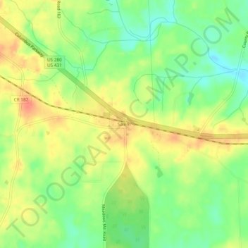
Name: Salem topographic map, elevation, terrain.
Location: Salem, Lee County, Alabama, United States (32.57680 -85.25855 32.61680 -85.21855)
Average elevation: 198 m
Minimum elevation: 171 m
Maximum elevation: 224 m
Make a donation
Gear up for your next adventure:
As an Amazon Associate, this site earns from qualifying purchases at no extra cost to you.
Other topographic maps
Click on a map to view its topography, its elevation and its terrain.
Auburn
United States > Alabama > Lee County
The southwest and west regions of the city on the plateau are marked by rolling plains and savannahs, with the undeveloped portion primarily being used for cattle grazing and ranching. South of this region sits the coastal plain, with sandy soil and pine forest. Parts of north Auburn have much more rugged…
Average elevation: 200 m

Make a donation
Gear up for your next adventure:
As an Amazon Associate, this site earns from qualifying purchases at no extra cost to you.
Auburn
United States > Alabama > Lee County
The southwest and west regions of the city on the plateau are marked by rolling plains and savannahs, with the undeveloped portion primarily being used for cattle grazing and ranching. South of this region sits the coastal plain, with sandy soil and pine forest. Parts of north Auburn have much more rugged…
Average elevation: 200 m
Auburn
United States > Alabama > Lee County
The southwest and west regions of the city on the plateau are marked by rolling plains and savannahs, with the undeveloped portion primarily being used for cattle grazing and ranching. South of this region sits the coastal plain, with sandy soil and pine forest. Parts of north Auburn have much more rugged…
Average elevation: 200 m
Make a donation
Gear up for your next adventure:
As an Amazon Associate, this site earns from qualifying purchases at no extra cost to you.
Auburn
United States > Alabama > Lee County
The southwest and west regions of the city on the plateau are marked by rolling plains and savannahs, with the undeveloped portion primarily being used for cattle grazing and ranching. South of this region sits the coastal plain, with sandy soil and pine forest. Parts of north Auburn have much more rugged…
Average elevation: 208 m
Auburn
United States > Alabama > Lee County
The southwest and west regions of the city on the plateau are marked by rolling plains and savannahs, with the undeveloped portion primarily being used for cattle grazing and ranching. South of this region sits the coastal plain, with sandy soil and pine forest. Parts of north Auburn have much more rugged…
Average elevation: 200 m