
Make a donation
Gear up for your next adventure:
As an Amazon Associate, this site earns from qualifying purchases at no extra cost to you.
Selwerd topographic map
Click on the map to display elevation.
Make a donation
Gear up for your next adventure:
As an Amazon Associate, this site earns from qualifying purchases at no extra cost to you.
About this map
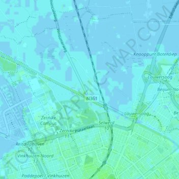
Name: Selwerd topographic map, elevation, terrain.
Location: Selwerd, Oost, Groningen, Nederland, 9738 TB, Nederland (53.22637 6.53090 53.26637 6.57090)
Average elevation: 1 m
Minimum elevation: -4 m
Maximum elevation: 7 m
Make a donation
Gear up for your next adventure:
As an Amazon Associate, this site earns from qualifying purchases at no extra cost to you.
Other topographic maps
Click on a map to view its topography, its elevation and its terrain.
Groningen
Nederland > Groningen > Groningen
Groningen ontwikkelde zich in ruim tweehonderd jaar van een gemeente met ruim 23.000 inwoners in 1795 tot een gemeente met ruim 200.000 inwoners in 2016. Een deel van de stijging is te danken aan de trek van het platteland naar de stad en de trek van studenten uit andere provincies en landen naar Groningen.…
Average elevation: 1 m
Make a donation
Gear up for your next adventure:
As an Amazon Associate, this site earns from qualifying purchases at no extra cost to you.
Make a donation
Gear up for your next adventure:
As an Amazon Associate, this site earns from qualifying purchases at no extra cost to you.