
East Java topographic map
Click on the map to display elevation.
East Java
East Java has a tropical monsoon and savanna climate at lower elevation and subtropical at higher elevation. Compared with the western part of Java Island, East Java in general has less rainfall. Average rainfall is 1,900 mm per year, with a rainy season during the 100 days. The average temperature ranges between 19-34 °C. Temperatures in the lower mountain areas, and even in areas Ranu Pani (slopes of Mount Semeru), temperatures can reach –4 °C, causing a frost and fall of light snow.
About this map
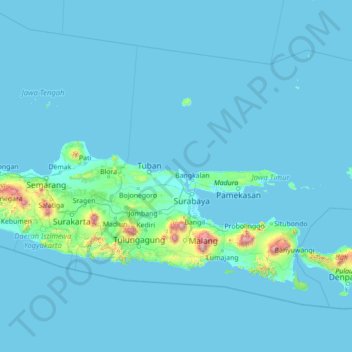
Name: East Java topographic map, elevation, terrain.
Location: East Java, Java, Indonesia (-9.03014 110.88160 -4.89269 116.48418)
Average elevation: 62 m
Minimum elevation: -1 m
Maximum elevation: 3,481 m
Other topographic maps
Click on a map to view its topography, its elevation and its terrain.
Rinjani
Indonesia > West Nusa Tenggara
Mount Rinjani (Indonesian: Gunung Rinjani; Sasak: ᬕᬸᬦ᭄ᬗᬸᬂ᭞ᬭᬶᬦ᭄ᬚᬦᬶ, romanized: gunong rinjani) is an active stratovolcano situated in regencial North Lombok of West Nusa Tenggara province on the Indonesian island of Lombok. It reaches an elevation of 3,726 metres (12,224 ft),…
Average elevation: 3,071 m
Bukit Bintang
Indonesia > Special Region of Yogyakarta > Gunungkidul Regency > Patuk > Patuk > Ngasemayu
Average elevation: 201 m
Bojonggenteng
Indonesia > West Java > Bogor > Parung Panjang > Gintung Cilejet
Average elevation: 49 m
Bukit Klangon
Indonesia > Special Region of Yogyakarta > Sleman Regency > Pakem
Average elevation: 1,351 m
Bekasi
The City of Bekasi is a part of the Bekasi river basin, located in the downstream area of the basin with slopes ranging from 0 to 2% and elevations between 11 meters to 81 meters above sea level. The city of Bekasi is part of the Bekasi river basin and is located in the downstream area of the basin, with a…
Average elevation: 23 m
Atambua
Indonesia > East Nusa Tenggara > Belu
The town stretches 8.5 km from north to south and 5 km from east to west, and is in the north of the western half of Timor Island. The town is located at an altitude of about 350 m above sea level with temperatures ranging between 23 and 35 degrees Celsius.
Average elevation: 366 m
Pringwulung
Indonesia > Special Region of Yogyakarta > Sleman Regency > Condongcatur
Average elevation: 141 m