
Thank you for supporting this site ❤️
Make a donation
Make a donation
Gear up for your next adventure:
As an Amazon Associate, this site earns from qualifying purchases at no extra cost to you.
Tapalpa topographic map
Click on the map to display elevation.
Thank you for supporting this site ❤️
Make a donation
Make a donation
Gear up for your next adventure:
As an Amazon Associate, this site earns from qualifying purchases at no extra cost to you.
About this map
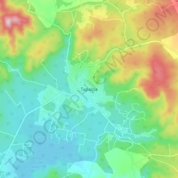
Name: Tapalpa topographic map, elevation, terrain.
Location: Tapalpa, Región Sur, Jalisco, 49340, Mexico (19.90490 -103.79760 19.98490 -103.71760)
Average elevation: 2,148 m
Minimum elevation: 1,999 m
Maximum elevation: 2,485 m
Thank you for supporting this site ❤️
Make a donation
Make a donation
Gear up for your next adventure:
As an Amazon Associate, this site earns from qualifying purchases at no extra cost to you.