
Make a donation
Gear up for your next adventure:
As an Amazon Associate, this site earns from qualifying purchases at no extra cost to you.
Zhob topographic map
Click on the map to display elevation.
Make a donation
Gear up for your next adventure:
As an Amazon Associate, this site earns from qualifying purchases at no extra cost to you.
Zhob
Zhob has a semi-arid climate (Köppen BSh). Its rainfall is high enough to avoid the arid climate category found at lower elevations. Zhob receive rainfall on occasions from the monsoon, though this occurs very erratically.
Make a donation
Gear up for your next adventure:
As an Amazon Associate, this site earns from qualifying purchases at no extra cost to you.
About this map
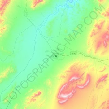
Name: Zhob topographic map, elevation, terrain.
Average elevation: 1,569 m
Minimum elevation: 1,258 m
Maximum elevation: 2,351 m
Make a donation
Gear up for your next adventure:
As an Amazon Associate, this site earns from qualifying purchases at no extra cost to you.
Other topographic maps
Click on a map to view its topography, its elevation and its terrain.