Geolocate

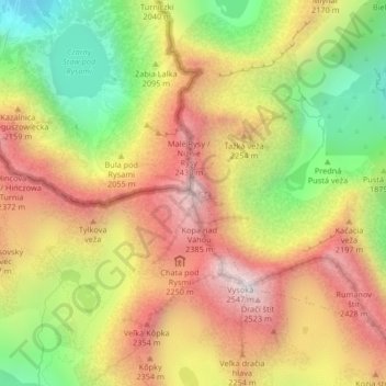
Rysy topographic map

Click on the map to display elevation.

Rysy

It is possible to reach the peak from the Slovak side, starting at Štrbské pleso and passing Chata pod Rysmi, a mountain chalet at an altitude of 2,250 m (7,380 ft). Between November 1 and June 15, the trail and chalet on the Slovak side are closed.

Wikipedia (CC-BY-SA 3.0)

About this map

Name: Rysy topographic map, elevation, terrain.

Location: Rysy, Vysoké Tatry, District of Poprad, Region of Prešov, Slovakia (49.17927 20.08841 49.17937 20.08851)

Average elevation: 2,005 m

Minimum elevation: 1,423 m

Maximum elevation: 2,528 m

Gear up for your next adventure:

👖Hiking Trousers - Durable trousers designed for rough terrain
🧼Camping Hygiene Kits - Compact hygiene essentials for outdoor stays
🩹Hiking First Aid Kits - Compact medical kits tailored for trail injuries and emergencies
🎒Hiking Backpacks - Comfortable backpacks for day hikes and multi-day treks
🎿Telescopic Trekking Poles - Reduces knee strain on steep topographic descents

As an Amazon Associate, this site earns from qualifying purchases at no extra cost to you.