
Thank you for supporting this site ❤️
Make a donation
Make a donation
Gear up for your next adventure:
As an Amazon Associate, this site earns from qualifying purchases at no extra cost to you.
Saint-Hubert-de-Rivière-du-Loup topographic map
Click on the map to display elevation.
Thank you for supporting this site ❤️
Make a donation
Make a donation
Gear up for your next adventure:
As an Amazon Associate, this site earns from qualifying purchases at no extra cost to you.
About this map
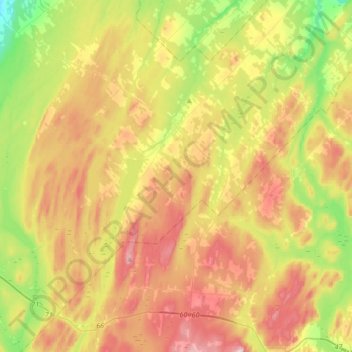
Name: Saint-Hubert-de-Rivière-du-Loup topographic map, elevation, terrain.
Average elevation: 341 m
Minimum elevation: 153 m
Maximum elevation: 564 m
Thank you for supporting this site ❤️
Make a donation
Make a donation
Gear up for your next adventure:
As an Amazon Associate, this site earns from qualifying purchases at no extra cost to you.
Other topographic maps
Click on a map to view its topography, its elevation and its terrain.
Phare de l'Île Verte
Canada > Québec > Rivière-du-Loup (MRC) > Notre-Dame-des-Sept-Douleurs
Average elevation: 12 m