Geolocate

Grünbach topographic map

Interactive map

Click on the map to display elevation.

About this map

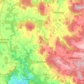
Name: Grünbach topographic map, elevation, terrain.

Location: Grünbach, Bezirk Freistadt, 4264, Austria (48.51405 14.48994 48.59871 14.60278)

Average elevation: 753 m

Minimum elevation: 553 m

Maximum elevation: 957 m

Other topographic maps

Click on a map to view its topography, its elevation and its terrain.

Unterarzing

Austria > Bezirk Freistadt > St. Leonhard bei Freistadt

Unterarzing, St. Leonhard bei Freistadt, Bezirk Freistadt, 4294, Austria

Average elevation: 744 m

Rainbach im Mühlkreis

Austria > Bezirk Freistadt

Rainbach im Mühlkreis, Bezirk Freistadt, 4261, Austria

Average elevation: 700 m

Steigersdorf

Austria > Bezirk Freistadt > Neumarkt im Mühlkreis

Steigersdorf, Neumarkt im Mühlkreis, Bezirk Freistadt, 4212, Austria

Average elevation: 653 m

Neumarkt im Mühlkreis

Austria > Bezirk Freistadt

Neumarkt im Mühlkreis, Bezirk Freistadt, 4212, Austria

Average elevation: 577 m