Geolocate

Les Preuses topographic map

Click on the map to display elevation.

About this map
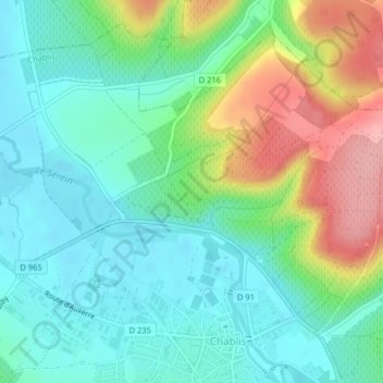
Name: Les Preuses topographic map, elevation, terrain.

Location: Les Preuses, Le Patis, Chablis, Auxerre, Yonne, Bourgogne-Franche-Comté, France métropolitaine, 89800, France (47.81574 3.78633 47.83574 3.80633)

Average elevation: 167 m

Minimum elevation: 126 m

Maximum elevation: 255 m

Other topographic maps

Click on a map to view its topography, its elevation and its terrain.

89800

France > Bourgogne-Franche-Comté > Yonne > Chablis

Average elevation: 219 m

Ru de Crioux

France > Bourgogne-Franche-Comté > Yonne > Chablis

Average elevation: 156 m

Fyé

France > Bourgogne-Franche-Comté > Yonne > Chablis

Son altitude varie entre 126 et 311 mètres.

Average elevation: 215 m

Poinchy

France > Bourgogne-Franche-Comté > Yonne > Chablis

Average elevation: 173 m

Gear up for your next adventure:

🥼Base Layers - Thermal base layers for temperature regulation
🎒Backpack Rain Covers - Universal waterproof covers to protect your gear from downpours
👖Hiking Trousers - Durable trousers designed for rough terrain
🛌Sleeping Bags - Warm and packable sleeping bags for outdoor nights
👟Men's Trail Running Shoes - Lightweight grip for fast movement over topographic contours

As an Amazon Associate, this site earns from qualifying purchases at no extra cost to you.