
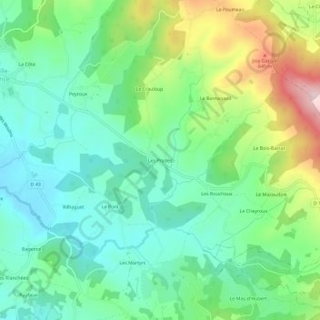
Les Prades topographic map
Interactive map
Click on the map to display elevation.
About this map
Name: Les Prades topographic map, elevation, terrain.
Average elevation: 510 m
Minimum elevation: 421 m
Maximum elevation: 708 m
Other topographic maps
Click on a map to view its topography, its elevation and its terrain.
La Grande Combe
France > Nouvelle-Aquitaine > Haute-Vienne > La Croisille-sur-Briance
La Grande Combe, La Croisille-sur-Briance, Limoges, Haute-Vienne, Nouvelle-Aquitaine, France métropolitaine, 87130, France
Average elevation: 462 m
Les Martyrs
France > Nouvelle-Aquitaine > Haute-Vienne > La Croisille-sur-Briance
Les Martyrs, La Croisille-sur-Briance, Limoges, Haute-Vienne, Nouvelle-Aquitaine, France métropolitaine, 87130, France
Average elevation: 483 m